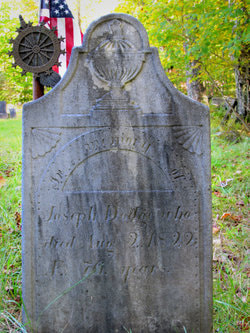
 MARKER NAME: Lt. Joseph Dodge, Revolutionary War Soldier
DESCRIPTION: DAR Insignia on Grave Stone LOCATION: Middletown Cemetery, Andover, Vermont CHAPTER: Susannah Lee Barlow DATE PLACED or DEDICATED: Andover, Vermont  MARKER NAME: Dana, Martha McKeown
DESCRIPTION: Memorial marker LOCATION: Newell House, 8089 Champoeg Road NE, St Paul, Oregon 97137-97 DIRECTIONS: From I-5, Take exit #278/Donald/Aurora National Historic District, 0.2 miles. Bear right onto Ehlen Road NE toward Champoeg Park 2.5 miles. Continue on Yergen Rd NE. 1.0 miles, turn right onto Case Road NE for about 1.4 miles. Continue on Champoeg Road NE, about 1.0 miles, Arrive at Champoeg Road NE. The trip takes 27.7 miles and 32 minutes. INSCRIPTION: IN MEMORY OF MRS. MARSHALL N. DANA HONORARY STATE REGENT PRESENTED BY SUSANNAH LEE BARLOW CHAPTER DAR DATE PLACED or DEDICATED: September 14, 1975  MARKER NAME: Holmes Donation Land Claim
DESCRIPTION: Bronze plaque LOCATION: Oregon City, on Thora B. Gardner Jr. High School Grounds, 180 Ethel St., Oregon City, Oregon 97045 DIRECTIONS: Turn on Ethel Street off of Linn Lane between Holmes and Warner Milne. The school is at the end of the street. The marker is under the flagpole in the front parking lot. INSCRIPTION: HOLMES CLAIM William L. and Louisa Holmes. Pioneers of 1843. Staked their claim here in 1844. In 1845 the Provisional Legislature met in Oregon City and elected Holmes Sheriff of Clackamas District which then extended eastward to the Rocky Mountains. He served for 11 years. Their Rose Farm Home here adjacent, was completed in 1848 and served as a political and social center for the territory in 1849. Territorial Governor Joseph Lane gave his inaugural address here Susannah Lee Barlow Chapter D A R 1968 DATE PLACED or DEDICATED: October 1, 1968
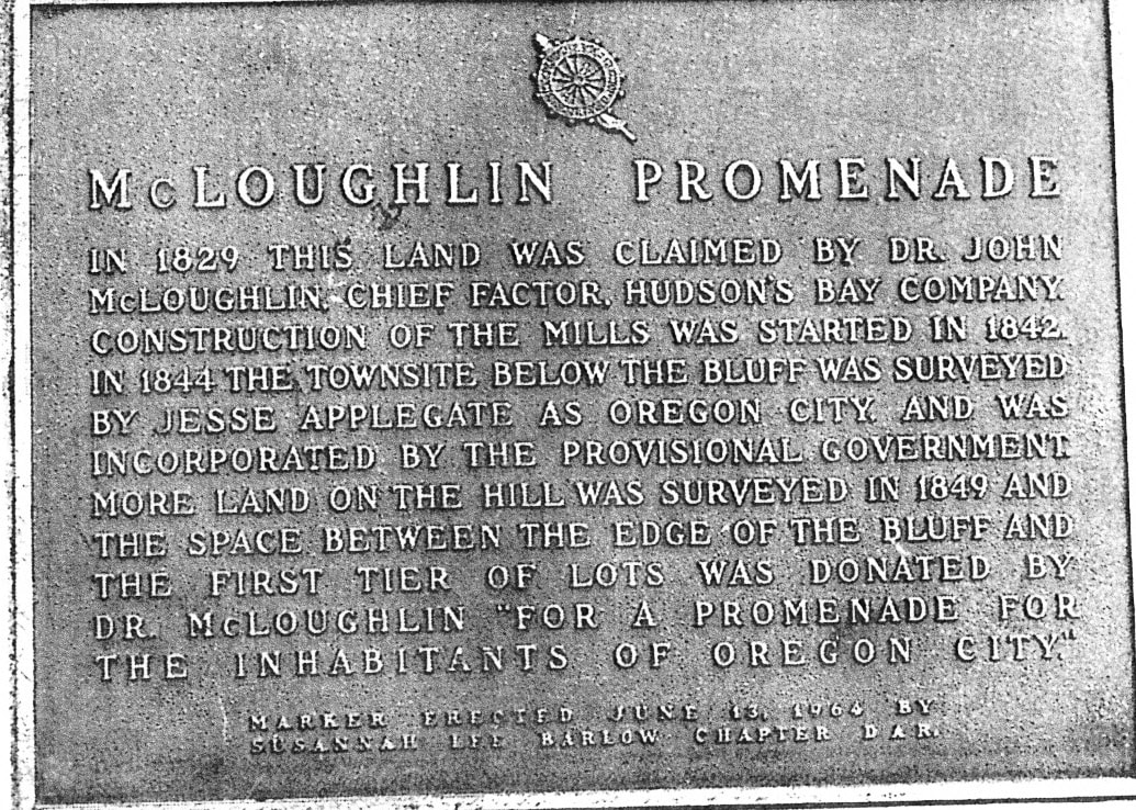
MARKER NAME: McLoughlin Promenade
DESCRIPTION: Marker LOCATION: Promenade and 5th, at edge of the cliff overlooking Oregon City. DIRECTIONS: Take exit #9/OR-99E/Oregon City/Gladstone. 0.3 miles, Turn left onto McLoughlin Blvd (OR-99E) toward OR-99E S/Canby. 0.5 miles, Turn left onto 10th St. 416 feet, Continue on Singer Hill Road. 0.1 miles, Turn right on High Street. The Promenade is behind buildings on the right. INSCRIPTION: McLoughlin Promenade In 1829 this land was claimed by Dr. John McLoughlin, Chief Factor, Hudson’s Bay Company. Construction of the mills was started in 1842. In 1844 the townsite below the bluff was surveyed By Jesse Applegate as Oregon City, and was Incorporated by the provisional government. More land on the hill was surveyed in 1849 and The space between the edge of the bluff and The first tier of lots was donated by Dr. John McLoughlin for a Promenade for The inhabitants of Oregon City.” Marker erected June 13, 1964 by Susannah Lee Barlow Chapter DAR. DATE PLACED or DEDICATED: June 13, 1964 DISPOSITION: Missing 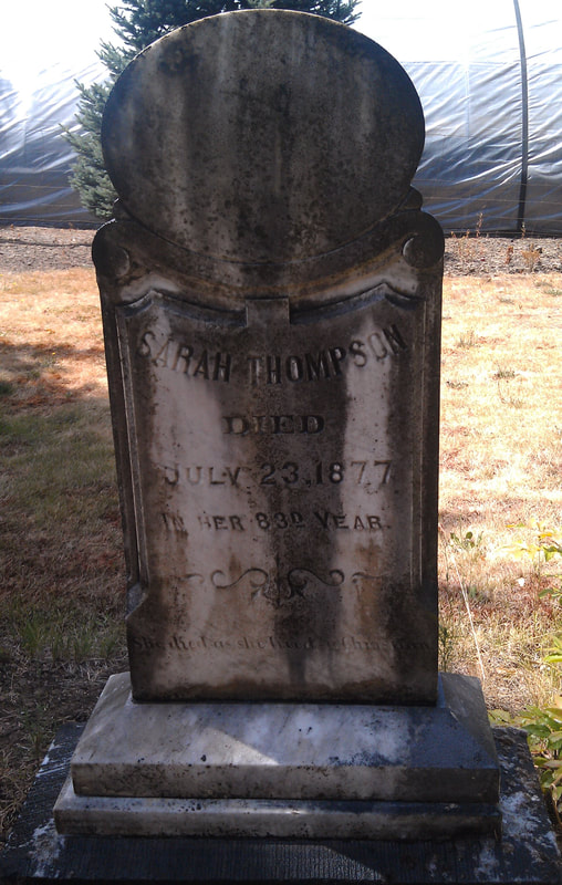 MARKER: Thompson, Sarah Mattock
DESCRIPTION: DAR Description “Grave marker – Daughter of a Revolutionary Soldier born 1794 died July 23, 1877. Parents names not given. Grave located next to Susannah Lee Barlow.” LOCATION: Barlow Cemetery, 24177-24349 South Barlow Road, Canby, Clackamas, Oregon. DIRECTIONS: South on Pacific Hwy. 99 through Canby. Turn west at stoplight on South Barlow Road. Cemetery is on the left. INSCRIPTION: (On Stone) Sarah Thompson died July 23, 1877 In her 83d year She died as she lived a Christian DATE PLACED or DEDICATED: Unknown DISPOSITION: Missing
MARKER NAME: Barlow, Susannah Lee (Real Daughter)
DESCRIPTION: Grave Marker LOCATION: Barlow Cemetery, 24177-24349 South Barlow Road, Canby, Clackamas, Oregon DIRECTIONS: South on Pacific Hwy. 99E through Canby. Turn west at stoplight on S. Barlow Road. Cemetery is on the left. DATE PLACED or DEDICATED: June 14, 1955  MARKER NAME: Dogwood Tree at the Neidermeyer Home
DESCRIPTION: Bronze plaque originally placed on the home grounds where the Dogwood tree was located at 3235 Harrison Street, Milwaukie, Oregon LOCATION: After the tree fell down in a storm, the stone was relocated at the Milwaukie Museum, 3737 SE Adams St., Milwaukie, Oregon, 97222-5917. DIRECTIONS: From McLoughlin Blvd (99E): exit onto Milwaukie Expressway (Hwy. 224) east. Turn north on 37th St. Go two blocks, at tracks turn right onto Railroad Ave., then immediate left into Museum parking lot. From I-205: exit onto Milwaukie Expressway (Hwy. 224) west. Turn north on 37 St., and follow directions above. INSCRIPTION: This Native Pacific Dogwood is over 100 Years old - the Largest in the United States - Height 65 feet, circum. 7 feet. Susannah Lee Barlow Chapter Daughters of the American Revolution April 27, 1952 DATE PLACED or DEDICATED: April 27, 1952 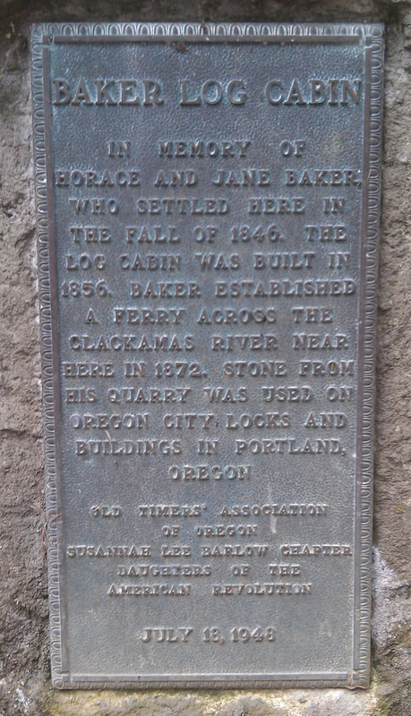 MARKER NAME: Baker Log Cabin DESCRIPTION: Bronze Tablet LOCATION: Carver, Clackamas County, Oregon DIRECTIONS: From I-205, take Exit #12A at Clackamas onto Highway 212/224 for 3 1/2 miles. Internet mapping programs will find us as "Baker Cabin Site - Oregon City". Keep right at junction onto Highway 224, go 1 mile to Carver Junction. In Carver, bear to the right, down the hill, across the bridge. Turn left, go about 1/8 mile to S. Hattan Road (across from County Park). Turn right, up the hill (heading south), go about 1/8 mile to junction of S. Gronlund Road. Baker Cabin and Pioneer Church Historical Site is on the right. From I-205: Take Exit #10, Hwy 213, east toward Oregon City for 1/8 mile. Take first right, turn right again to cross under the highway. Continue through the round-about onto Clackamas River Road. If Clackamas River Road is closed; detour by taking a right turn off of Clackamas River Road onto S. Forsythe Rd. Follow Forsythe approx. 5 miles to 1st stop sign at S. Bradley Rd. Turn right on S. Bradley. Then take first left onto S. Gronlund Rd. Proceed down the hill to BCHS site at junction with S. Hattan Rd. If South Clackamas River Road is open; proceed about 5 - 6 miles to stop sign. Continue straight ahead and take next right (south) onto S. Hattan Rd. Go up the hill about 1/8 mile to site at junction with South Gronlund Road. The Baker Cabin and Pioneer Church Historical Site is on the right. INSCRIPTION: Baker Log Cabin In memory of Horace and Jane Baker, who settled here in the fall of 1846. The log cabin was built in 1856. Baker established a Ferry across the Clackamas River near here in 1872. Stone from his quarry was used on Oregon City Locks and buildings in Portland, Oregon Old Timers Association of Oregon Susannah Lee Barlow Chapter Daughters of the American Revolution July 18, 1948 DATE PLACED or DEDICATED: July 18, 1948  MARKER NAME: Dr. Forbes Barclay
DESCRIPTION: Bronze Tablet LOCATION: Barclay House, 719 Center Street, Oregon City, Oregon DIRECTIONS: From I-205, Take exit #9/OR-99E/Oregon City/Gladstone for 0.3 miles. Turn left onto McLoughlin Blvd (OR-99E) toward OR-99E, S. Canby, for 0.5 miles, Turn left onto 10th St. 416 feet. Continue on Singer Hill Road for 0.1 miles. Bear left onto 7th Street for 180 feet, turn left onto Center Street for 150 feet. INSCRIPTION: DR. FORBES BARCLAY 1812-1873 Dr. Forbes Barclay left Scotland in 1839 for Fort Vancouver, (Washington), where He became Chief Physician for Hudson's Bay Company. He moved to Oregon City in 1850 where he practiced medicine for many years. He was one of Oregon City's Early Mayors, Councilman for 9 years, Coroner for 18 years, and Superintendent of the first public school for 15 years. Susannah Lee Barlow Chapter Daughters of the American Revolution Dedicated August 15th, 1948 DATE PLACED or DEDICATED: August 15, 1948 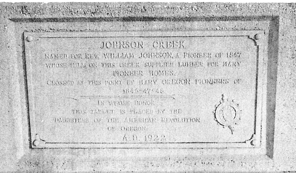 MARKER NAME: Johnson Creek
DESCRIPTION: Bronze Plaque LOCATION: Bridge over Johnson Creek, Milwaukie INSCRIPTION: JOHNSON CREEK Named for Rev. William Johnson, a Pioneer of 1867 Whose mill on this creek supplied lumber for many Pioneer homes. Crossed at this point by many Oregon pioneers of 1846-47-48 In whose honor This tablet is placed by the Daughters of the American Revolution Of Oregon A.D. 1922 DATE PLACED or DEDICATED: March 1923 DISPOSITION: Removed during the installation of the current, county bridge. In storage or lost.  MARKER NAME: The Barlow Monument
DESCRIPTION: Two bronze tablets. Second tablet inscribed. Original monument a large boulder erected by Sons and Daughters of Oregon Pioneers in 1923 and dedicated July 7, 1925. Bronze tablet on large boulder to Susannah Lee Barlow, wife of Samuel K. Barlow. LOCATION: Mt. Hood Loop Highway just east of Government Camp in Barlow Monument State Park on 25 foot plot. The monument is directly across the street from the Mt. Hood Cultural Center and Museum, 88900 E Hwy 26, Business Loop, P.O. Box 55, Government Camp, Oregon 97028. INSCRIPTION: Susannah Lee Barlow wife of S. K. Barlow a Real Daughter of the American Revolution and the real Madonna of the Barlow Trail. Arrived in Oregon City December 25, 1845. Placed by Susannah Lee Barlow and Multnomah Chapters D.A.R. 1923 DATE PLACED or DEDICATED: 1923 |

The content contained herein does not necessarily represent the position of the National Society Daughters of the American Revolution (NSDAR or DAR). Hyperlinks to other sites are not the responsibility of the NSDAR, the state organizations, or individual DAR chapters. Please contact our webmaster with questions. Last updated: July 26, 2022 |
SUSANNAH LEE BARLOW CHAPTER, DAR